ERS SAR
ERS SAR data are being used for the creation of a digital elevation model (DEM) in order to provide accurate topographic information of the study area. ERS Tandem data are used to create an interferogram, which is then used to create a DEM. The DEM will eventually be used in the creation of a three-dimensional visualization, which will show the relationship between topography and ground cover, and simulate change in ground features. This gives us a reliable basis of developing a geographic information system focusing on the archaeological sites of interest.
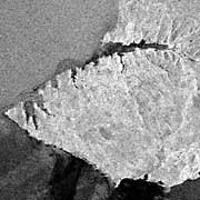
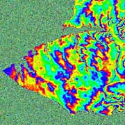
On the
left is the 1994 SAR image and,
right, its phase diagram created by interferometry. Phase-unwrapping remains to be finished before the final DEM is available for further analysis.
Back to Remotely Sensed Data
|

Last Modified: Wed Apr 14, 1999
CSR/TSGC Team Web
|


