
|
INSAR - Interferometric SAR
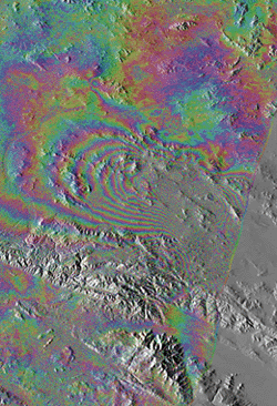
INTERFEROMETRIC
FRINGES (colored bands) obtained from a sequence of radar scans by
the ERS-1 satellite show the deformation of the ground caused by
an earthquake near Landers, Calif., in 1992. Each cycle of interference colors
(red through blue) represents an additional 28 millimeters of ground motion in
the direction of the satellite. The radar interference caused by the mountainous
relief of the area (black-and-white background) was removed to reveal this
pattern of ground deformation.
Subsidence
Mapping in Houston, TX and
Phoenix, AZ
- Subsidence mapping via SAR interferometry
Chora of Chersonesos
(Sevastopol), Ukraine
- Creation of Digital Elevation Models using SAR
interferometry
Bolivar Peninsula, Texas
- Determining Surface and Vegetation Heights form
Interferometric Radar
|
|
|
