
|
Remote Sensing Research
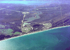
Aerial photograph of launch pads 39-A and 39-B
Phase I:
1997-1998. Multiresolution Image Analysis for Environmental Mapping
CSR is working to develop automated classification algorithms to accurately identify different vegetation types and locate non-native or introduced flora. The datasets that CSR is working with includes Thematic Mapper (TM), SPOT multispectral and panchromatic, and SIR-C (Imaging Radar).
Phase II: 1998 -
1999. Classification of Wetland Vegetation using AVIRIS Data
A need exists at KSC to develop a protocol which can quickly and accurately classify and map the distribution of vegetation types within the impoundments using remotely sensed data acquired over a multi-year time horizon. The increased spectral resolution of hyperspectral imagery shows increased potential for accurately mapping marsh vegetation versus broad-band sensors. The research performed for this project consists of the classification of wetland vegetation at the Kennedy Space Center, Florida using hyperspectral imagery.
Phase III: 1999 -
2000. Extraction of
Digital Elevation Models for
Airborne Laser Terrain
Mapping Data
Topographic information can
now be derived from a
variety of approaches and
instruments including laser
altimetry. Extraction
of actual terrain in
vegetated areas is a
difficult problem for all
sensors. The small
footprint of the airborne
laser terrain (ALTM) data
coupled with the potential
for acquiring multiple
returns for each outgoing
pulse now offers new
potential for obtaining more
accurate digital elevation
models (DEM's) which are
critical for many
applications such as
hydrology and shoreline
mapping.
|

Last Modified: Mon June 14, 1999
CSR/TSGC Team Web
|
|
|
|

