Finke River: Area Description

Landscape
surrounding the Finke River |
The
Finke River Gorge of the
Central Australian Ranges
near Alice Springs rises
from the Western MacDonnell
Ranges, flows through
pediments, crosses the
Missionary Plain, enters the
James Ranges, and forms a
deep meandering gorge in
Hermannsburg Sandstone.
Near Palm Valley, the
Finke River has cut a
spectacular gorge across the
trend of the ranges. The
crests of the sandstone
ridges are beveled by
regional planation. This
surface appears to be
regionally deformed, but
quantitative analysis of
topography is required to
establish this hypothesis
and its consequences.
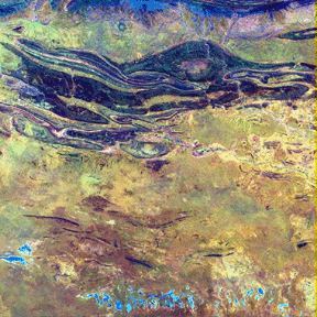
Landsat
TM data of Finke Gorge
National Park
As
shown in the Landsat scene
above, the region is
composed of mountains, hills
and low hills with a general
east-west trend and very
little flat country, except
for the Missionary Plain.
There are several large
drainage systems draining
east or west ultimately
leading to the Finke River
or Ellery Creek. The geology
of the area is one of great
interest and complexity,
resulting in a wide variety
of vegetation and soil types1. The assemblages of
species which make up the
vegetation of the area vary
widely and produce a complex
of many types in a
relatively small area.
Superimposed on this natural
complexity is a mosaic of
changes caused by such
things as fire history,
climate and land use. The
most widespread vegetation
types in the area are spars
woodland, more commonly
known as shrubland over
hummock or tussock
grasslands. Acacias are the
most dominant species of the
woodland on the lower
elevations, being replace by
various mallees on higher
ground.
As an ancient inland mountain river system, the Finke
River area also provides
excellent opportunities for
quantitative paleoflood
hydrology both in Australia
and other arid environments
where extreme events define
the morphology of the
riverine system.
The history of the
drainage evolution of the
region is contained in
paleomeanders:
the Finke exhibits
well-defined paleomeanders
associated with at least two
previous locations of the
river channel, and
additional paleomeanders
exist in both the Missionary
Plain and Palm Valley.
Unfortunately,
topographic information has
been inadequate for either
regional or local studies.
Because both low relief
plains and mountain ranges
are located in close
proximity, it is important
to provide the overall
regional topography and the
higher spatial resolution
elevation information as
well. Thus, the Finke River
area is an excellent site
for developing a variable
resolution DEM based on ERS
repeat pass and JPL TOPSAR
interferometric data.
Two CSR projects are focusing on development of the
methodologies to support
analysis of flooding events: 1) An Army
Research Office funded study
whose goal is to develop and
apply image analysis
techniques to geologic
studies; and 2)
A NASA funded effort
to develop and test remotely
sensed derived inputs for
hydrological models.

Finke River Gorge |
1Wildlife Research Conservation Commission of the Northern Territory, "Vegetation and Soil Survey in the West MacDonnell Ranges" |

Last Modified: Wed Apr 14, 1999
CSR/TSGC Team Web
|


