
Position measurements using multiple techniques, like Satellite Laser Ranging (SLR) and Very Long Baseline Interferometry (VLBI), from multiple reference stations are combined to produce one reference frame, the International Terrestrial Reference Frame (ITRF). A major component to the realization of an accurate ITRF using multiple technique stations is to consistently obtain millimeter to sub-millimeter accurate survey ties between the instrument centers of these reference stations.
MGO has undertaken an effort to push the limit of allowable geodetic station layouts and locations into the ITRF. A framework is being developed for determining the local tie between the SGSLR and VLBI geodetic observing system (VGOS) instruments at MGO using electronic distance measurement. These data can be directly compared to GNSS observations. With the aid of professional surveyor and metrologist, John Griffin, the existing state-of-the-art metrology and surveying technology and techniques are applied to reduce errors and get to the core of the measurements and the data analysis.
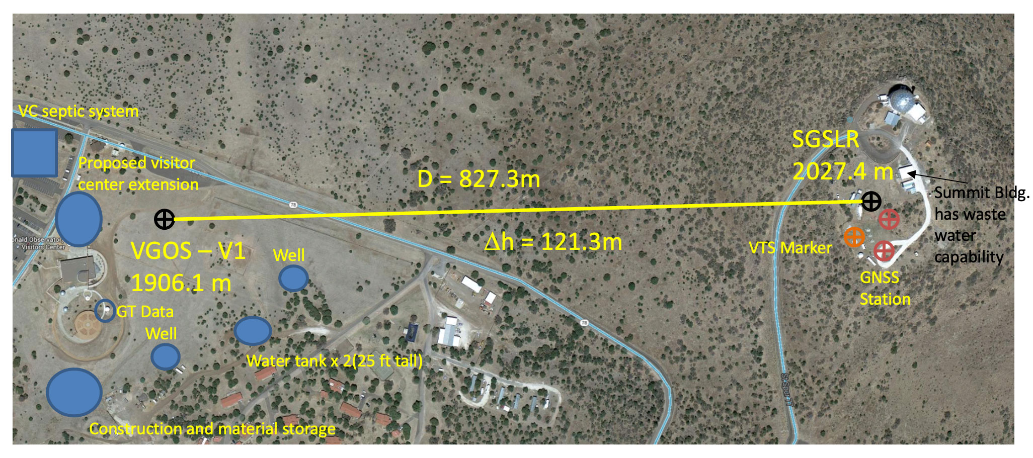
MGO will have an established framework of procedures and analysis methods for measuring and estimating a millimeter accurate survey tie across a kilometer baseline with significant elevation change between the constructed VGOS telescope and the soon-to-be-completed SGSLR at McDonald Geodetic Observatory. The sites are separated by approximately 1km horizontal and 120m vertical distance. This framework should be translatable to other observatories, especially to those whose geometries lie outside the recommended configurations set by the global geodetic observing system (GGOS).

Design of the Network
Measurement of the tie between the two instrument centers, VGOS and SGSLR, involves two sets of six permanent target monuments (TMs) around each site, forming two local ground control networks (LGCNs). The instruments include two Leica TS-30 total stations placed in a braced quadrilateral formation that covers the kilometer baseline between the two instrument sites. The target monuments are surveyed to sub-mm precision and accuracy and used to store known coordinates through which a local reference frame is defined, the instrument centers are located, and the baseline tie is measured.
The baseline tie is created with a formation of four floating instrument positions, two near each LGCN site. These positions do not need to be permanent over multiple campaigns because the known position and orientation of the local reference frame is stored in the permanent TM positions. They only need to remain stable for the duration of each survey session. The formation of floating instrument positions is called the braced quadrilateral (BQ), coined during the pre-analysis simulations that determined this shape produced the tightest error ellipses for measuring the kilometer baseline. Every point in the formation is surveyed from three other points, with cross diagonal observations “bracing” the shape of the network three dimensionally.
Campaign Structure
Initial data collection occurred over the course of eleven multi-day campaigns spread out bi-monthly over the two-year project period. During each campaign, one session of metrology observation was conducted each day. Stable atmospheric conditions are required for EDM operation, so campaigns began early in the morning, when winds were calm. Sessions usually lasted 4-6 hours and would last until early afternoon.
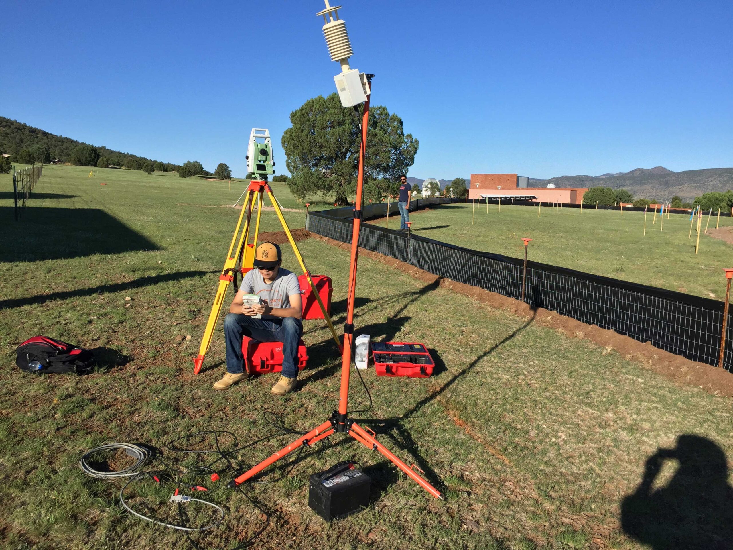
A session begins with the set-up phase where reflectors and instrument position (IP) tripods are placed, and the meteorology collection is initialized at the VLBI site. The SLR site at Mt. Fowlkes is equipped with a weather station for use with the astronomical telescopes. During the metrology phase, we collect 32 sets of measurements (observations to all targets in the network) from each IP location: raw range, vertical angle (from locally defined vertical), and horizontal angle (defined by initial reference direction).
The total station is operated with Automatic Target Recognition (ATR), a mode in which the total station observes pre-defined targets for a specific number of sets without user input/interaction. The instrument automatically points to a pre-defined target (horizontal and vertical angle defined), sends out a laser pulse, and records the return pattern of the reflected laser from the target to the instrument on a charge coupled device (CCD). Given the speed of light in the atmosphere, the time it takes for the laser pulse to return to the instrument after being fired determines the distance to the target.
Future Work
While the VGOS instrument is fully operational, the SGSLR is still being built. During the phase 2 extension of the work on precision survey ties, the tie will be progressed by surveying from the LGCNs to the instrument center of the VGOS and the closest stable point to the future location of the SGLSR. Then repeatability will be established through multiple survey campaigns. The ties to the instrument centers are believed to be an order of magnitude more accurate than the network and baseline ties due to the distances considered. Therefore, they will not degrade the overall quality of the tie, barring any systematic biases in the measurement of the instrument centers themselves.
Contact Information:
John Griffin (john.griffin@jgsurvey.com)
Jullian Rivera (jullian.rivera@utexas.edu)