The data from MGO will also be used to support a range of scientific and societal applications, including:
- Global and Regional Sea-level Change
- Global Sea-level and Climate Parameters Variation
- Regional Coastal Hazards and Vulnerability Monitoring
- Assured Positioning, Navigation, and Timing
- Data contributions to the Global Geodetic Observing System (GGOS), a global network of geodetic instruments
Global and Regional Sea-level Change
Global mean sea level has risen about 8–9 inches (21–24 centimeters) since 1880, with about a third of it occurring in the last two-and-a-half decades 1.
Reconciliation of ocean and land changes at the coastal interface is necessary for both physical understanding and for planning purposes.
Such reconciliation – using data from tide-gauges, GPS receivers, and radar altimeters (toolsets that helped draw the image to the left) – relies on using the stable Terrestrial Reference Frame (TRF) that MGO helps to define.
In combination with other missions at the UT Center for Space Research, like the Gravity Recovery and Climate Experiment (GRACE) twin satellite mission, a better understanding of the impact of climate change on Earth’s sea-levels may be achieved on both local and global scales.
Sea level and climate science
Measurement and multi-technique synthesis of Global Mean Sea Level (GMSL), Relative Sea Level (RSL), and their variability rely on access to a long-term stable Terrestrial Reference Frame (TRF).
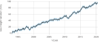
SATELLITE DATA: 1993 – PRESENT
Data source: Satellite sea level observations. Credit: GSFC/PO.DAAC
Accurate measurements of GMSL and RSL provide integral constraints that contribute to studies of diverse geophysical processes of interest to science and society, such as:
- Earth energy imbalances
- Changes in land-ocean water balance
- Changes in global overturning circulation (conveyor belt)
- Coastal nuisance flooding
- Changes in major coastal inundation severity and frequency (return period/recurrence intervals)
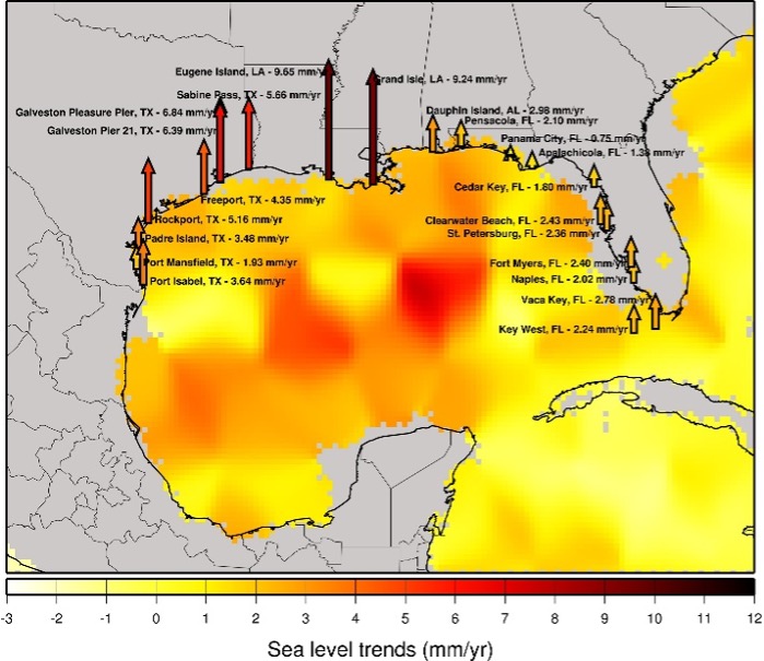
Regional Coastal Hazards and Vulnerability Monitoring


In many locations along the U.S. coastline, high-tide flooding is now 300% to more than 900% more frequent than it was 50 years ago 1. Each year, several hurricanes continue to batter the areas lining the Gulf of Mexico, leading to flooding and widespread destruction of property.
This trend has created a need to better integrate science and metrology in surveying for sea-level, storm surge, and coastal hazard studies, at both short-term and decadal scales. Specifically, progress made at MGO has contributed to better understanding these changes along the Gulf of Mexico coast, as the TRF that MGO helps to define is integral to effective hazards and vulnerability monitoring over time.
Assured Position, Navigation, and Timing – Landmarks for Modern Science
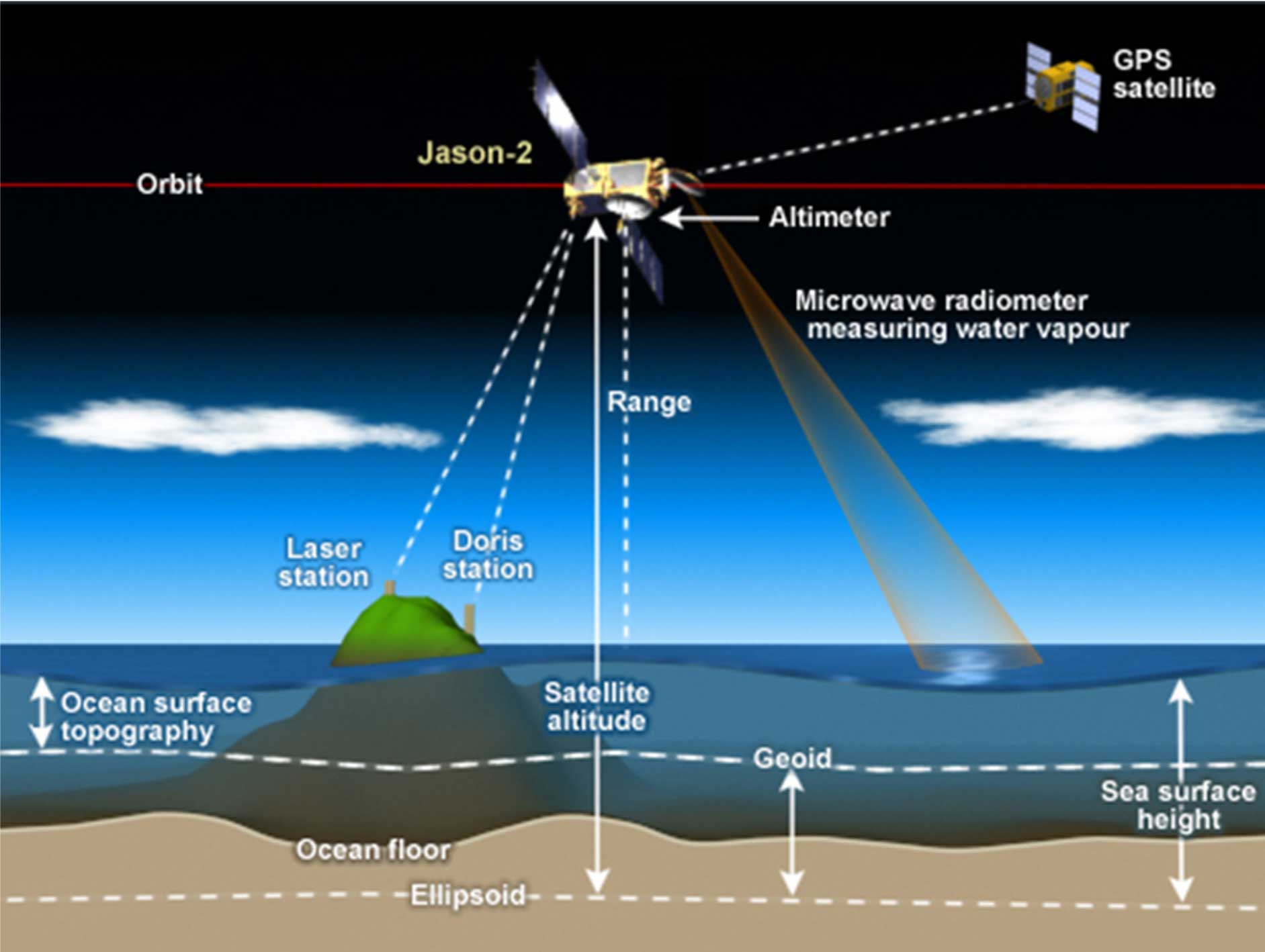
There are several measurements for which assured position, navigation, and timing (APNT) are required. For example, to measure the height of the sea-surface relative to the ocean floor, satellite-borne radar can measure the distance between its satellite and the sea-surface. However, to understand where the satellite is, its position relative to a known position on Earth must be measured. In theory, a satellite laser ranging station makes this measurement seemingly straightforward; but in practice it is much more complicated.
The same measurements (drawn in black and red in the above illustration) introduce ambiguity (drawn in green) in the measured sea-surface height, depending on the stability of the chosen landmark. This ambiguity reflects a frequent situation where there is not enough data with which to characterize how the measurement systems are moving relative to the origin. This makes it difficult to precisely interpret those (red and black) measurements – particularly those separated by decades.
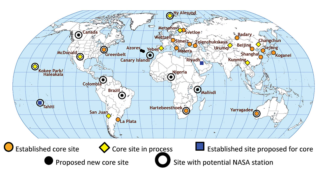
To minimize such global change measurement (green line) ambiguities, a global network of “most stable” landmarks is being established. This network employs a combination of instruments and measurement techniques located at such landmarks (also known as “core sites”) to characterize any motion occurring there over time with sufficient accuracy to contribute to the “realization stability goal” of 0.1 mm/year for the TRF.
MGO is to be one such landmark within the global network.
MGO is a part of and contributes to a global geodetic network of stable reference points to define the terrestrial reference frame. No individual technique can completely define the reference frame to the desired precision. Co-location of the various techniques is essential to tie the various techniques together, since each technique uses a different set of targets. Ideally, a fundamental (or core) geodetic site would include at least VLBI, SLR, and GNSS. MGO is intended to contribute to the global geodetic infrastructure by colocating multiple state-of-the-art geodetic instruments tied together by mm-level metrology. The data produced by the network of similar sites around the world are used to support support a range of scientific and societal applications in areas such as Earth observations, positioning, navigation, and timing.
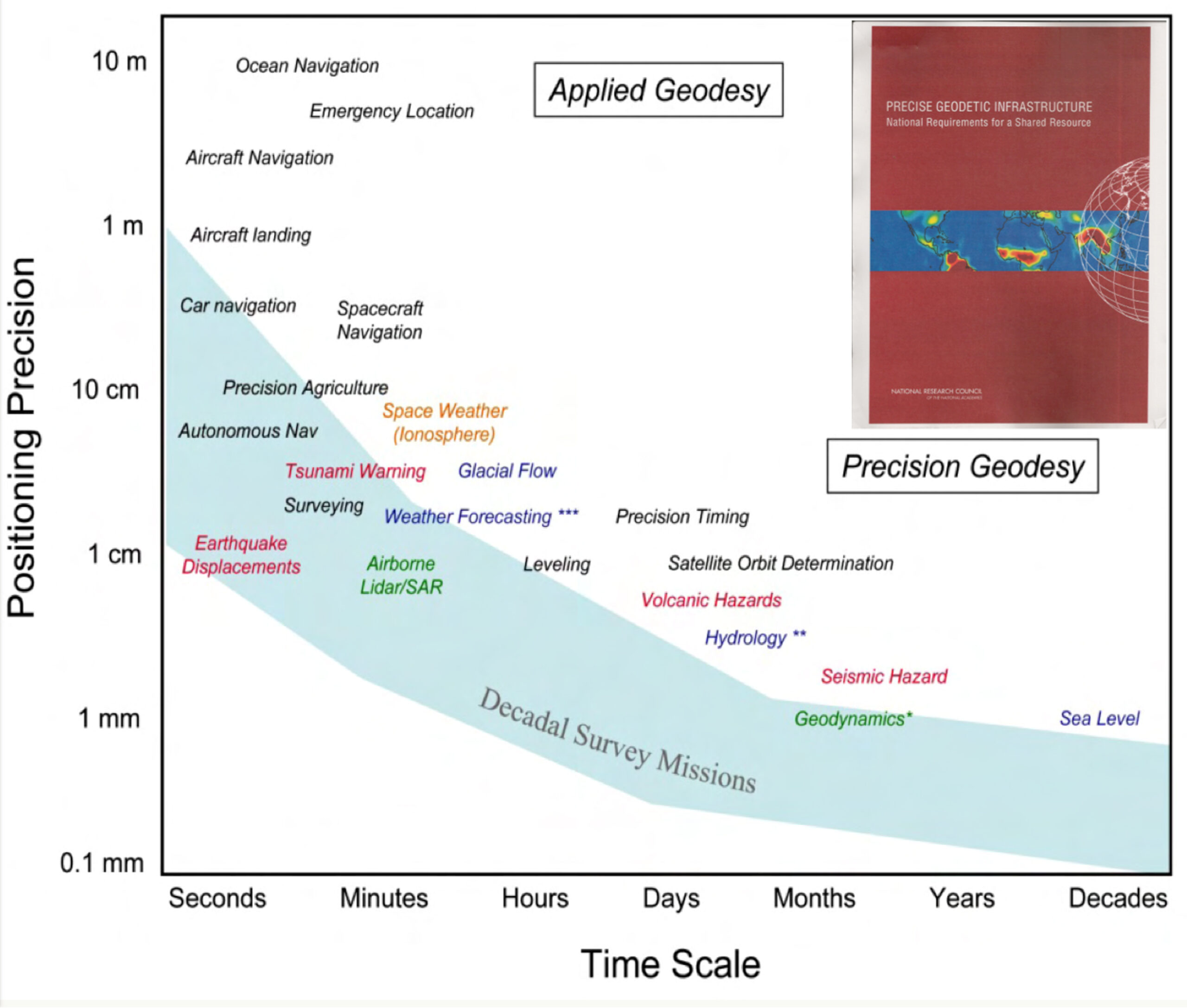
Applications Enabled by a Sub-millimeter Reference Frame
In addition to current day use of GPS in vehicles of all kinds, several important applications require the presence of a precise reference frame. As set forth in the graph below, they include aircraft navigation, weather forecasting, sea level tracking, and much more.