Radar Interferometry
Measurement of Land
Subsidence in Houston, Texas
Area Description
Houston urban development
began along Buffalo Bayou,
generally along present-day
central and east Houston.
After discovery of vast oil
reserves in the early 1900s,
the Channel became the
location of many
petrochemical refineries.
Significant industrial
development occurred during
World War II, when Houston
industry became a major
manufacturer of war
supplies. The influx
of war-time workers, the
development of an expressway
system during the 1950s and
an unprecedented lack of
city zoning laws quickly led
to urban sprawl. Most
recent Houston urban
development has been to the
north and west.
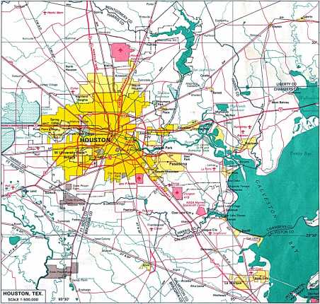
Houston map
Groundwater pumping for
residential and agricultural
use began shortly after the
discovery of a vast aquifer
system in the late 1880s.
Industrial groundwater usage
began with the opening of
the Ship Channel and
increased dramatically
during WW II. Not
until the formation of the
Harris-Galveston Coastal
Subsidence District in 1975
did surface water replace
groundwater usage in parts
of Houston.
Maximum subsidence has
occurred in the east Houston
suburb of Pasadena, where
more than 3 meters of
subsidence has been observed
along Buffalo Bayou.
In addition, differential
subsidence along
Houston-area growth faults
has caused extensive damage
to thousands of man-made
structures.
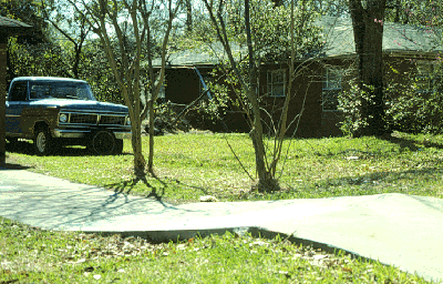
Houston growth
fault damage (photo by S.
Duncan Heron, Jr. - heron@eos.duke.edu)
Since switching to
surface water in the late
1970s, east Houston has seen
dramatic decreases in
overall subsidence rates.
Indeed, extensometer data
indicates 3 cm of rebound
over the past decade in the
Pasadena area as water
levels have recovered.
However, dramatic urban
development and continued
groundwater usage has
resulted in increased
subsidence rates in north
and west Houston.
SAR
Data

