Rain followed by warmer temperatures and longer days converge to trigger a green spring in Texas. 2019 highlights this appealing phenomenon.
For almost two decades, CSR has monitored the seasonal response of regional vegetation during periods of ample rainfall separated by prolonged droughts.
Satellite sensors can capture early indications of changing patterns in the vitality of Texas vegetation. By creating a time series of measurements collected by the Moderate Resolution Imaging Spectroradiometer (MODIS) instruments aboard NASA’s Terra and Aqua satellites, the reflection of near infrared and red light can be analyzed as surface conditions change. A high ratio of reflected near infrared to red radiation indicates a landscape of healthy, photosynthesizing plants, whereas a low ratio signals dormant, often drought-stressed vegetation.
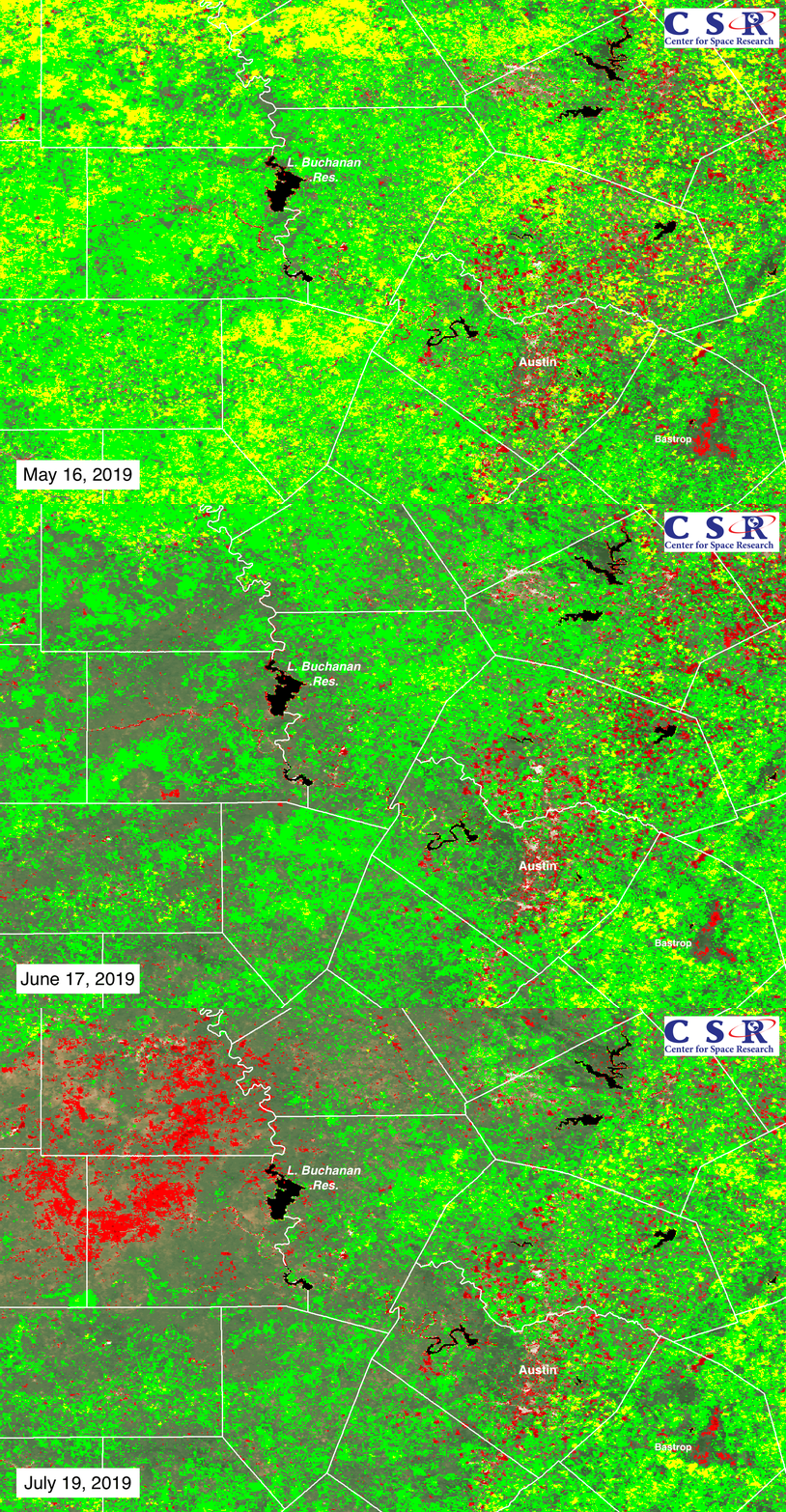
A sequence of three MODIS images of Central Texas near Austin uses a classification system to display seasonal changes in vegetation health. The images compare measurements made on dates in 2019 to the decadal averages on the same dates for measurements taken from 2001 to 2010. During the peak of spring on May 16, 2019, areas of bright green indicate ratios more than 5 percent higher than the 2001-10 decadal average for May 16, while patches of yellow indicate ratios greater than 10 percent higher. 2019 was an exceptionally green spring in Central Texas.
One month later, conditions were shifting, as the weather became drier in the Texas Hill Country to the west of Austin. On June 17, the formerly bright green areas were fading and some spots of red appeared marking places where the ratio of near infrared to red radiation fell more than 5 percent below the decadal average on that date. By July 19, with little rain and triple digit temperatures, the area west of Lake Buchanan Reservoir shows an expanse of red, where vegetation exhibits signs of increasing stress due to drought.
Note the small red area in the southeastern corner near Bastrop that appears in all three images. This is the burn scar left by a 34,000-acre wildfire that occurred in September 2011. In this case, the negative departure from the long-term average is not caused by the onset of drought, but is the result of lush green forest canopy burned to the ground by the fire. It could take another decade or longer to restore the former pine forest.
Will drought conditions spread across Texas during the summer of 2019? CSR will continue to monitor changing patterns in the response of vegetation. The satellite observations contribute to the baseline of physical measurements needed to document the regional impacts of both short-term and longer-term climate change.
For additional information, please contact Gordon Wells at gwells@csr.utexas.edu
