
“Monitoring Coastal Waves with ICESat-2“, was recently published in the Journal of Marine Science and Engineering by the Center’s James Dietrich and Matt Holwill characterizing coastal waves with ICESat-2.
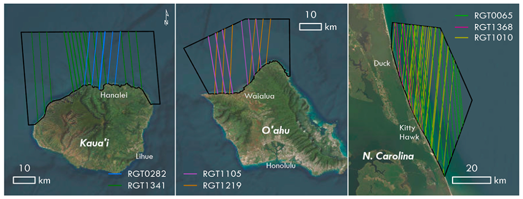
Abstract: The coastal zone faces an ever-growing risk associated with climate-driven change, including sea level rise and increased frequency of extreme natural hazards. Often the location and dynamism of coastal regions makes them a formidable environment to adequately study with in-situ methods. In this study we use Ice, Cloud, and land Elevation Satellite-2 (ICESat-2) to make measurements of basic wave parameters and wave directionality in the coastal zones of the Hawaiian Islands and North Carolina, USA. Our goal was to leverage as much of the full resolution data available in the ATL03 data product to generate wave metrics out from shore up to ~25 km. Using a combination of statistical and signal processing methods, including cross-correlation and wavelets, we can use ICESat-2 to generate basic wave metrics, including significant wave heights with an accuracy of ±0.5 m. In some profiles we can identify wave shoaling, which could be useful to infer bathymetry and coastal dynamics. In areas with complex wave dynamics, the nature of how ICESat-2 measures elevations (parallel laser altimetry beams) can make extracting some wave parameters, especially wavelength and directionality, more challenging. These wave metrics can provide important data in support of validating wave and tidal models and may also prove useful in extended ICESat-2 applications like bathymetric corrections and satellite-derived bathymetry.
Source: https://www.mdpi.com/2541920