
How Satellites and Telescopes are Tracking the Effects of Global Change, Down to the Millimeter
By Alexandra Witze
Air & Space Magazine
September 2019
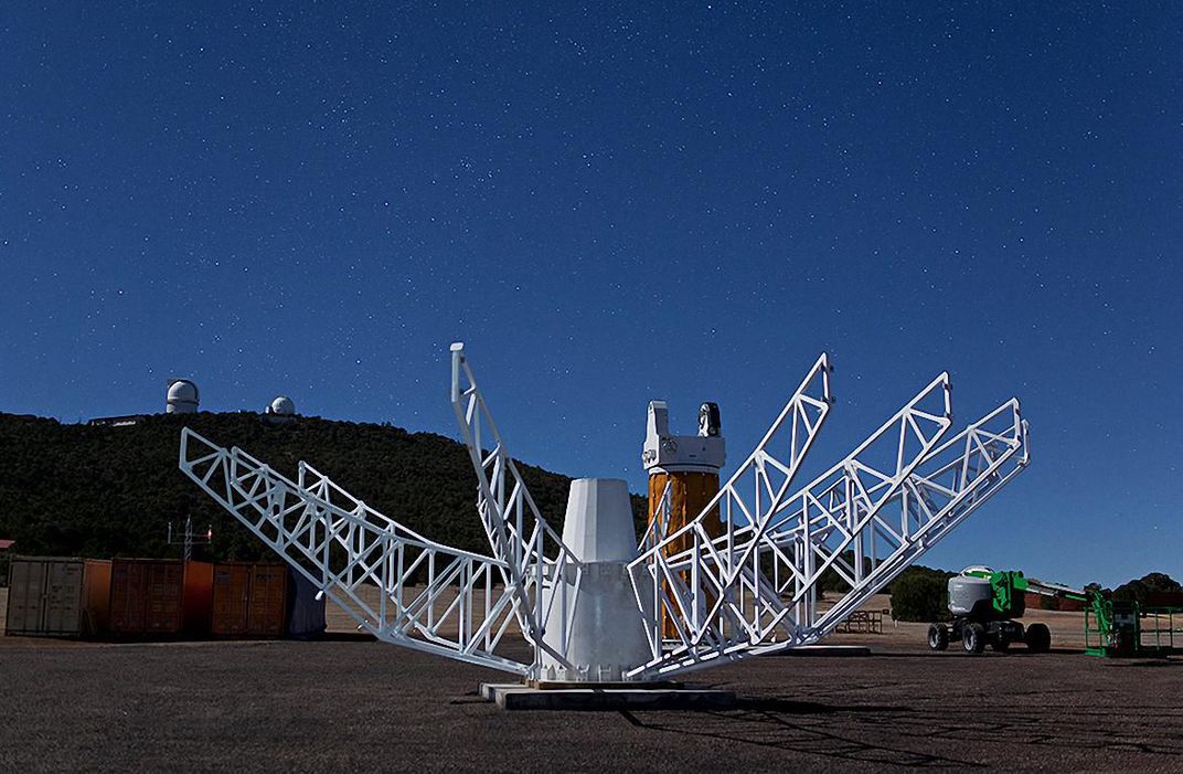
In the Davis Mountains of far west Texas, at the University of Texas McDonald Observatory, astronomers spend their nights peering at the stars through some of the world’s most powerful telescopes. Soon they’ll be adding a more down-to-Earth job. Within sight of the giant domes, NASA is installing a sprawling network of equipment to help researchers study planetary change.
Last July, engineers achieved first light on a towering radio antenna, 12 meters across, that watches for signals flashing from cosmic beacons called quasars located in the distant universe. Nearby, scientists have set up new global-positioning-system stations—tripods topped with bulbous heads that communicate with GPS satellites to determine their precise location on Earth’s surface. On a neighboring mountain, technicians plan to build a powerful laser system that can zap a beam of light up to a satellite, then clock how quickly it reflects back to Earth. Together, all this high-tech equipment will allow scientists to pinpoint individual spots of ground at McDonald Observatory to within millimeters.
Similar activities are going on all over the world. NASA is helping to upgrade Earth-measuring observatories from Tahiti to South Africa. By linking the McDonald measurements with the others, researchers aim to better understand how Earth’s shape, rotation, and gravity change over time.
Called geodesy, this field of science underlies almost every aspect of modern life, whether it’s using Google Maps to find the nearest coffee shop or determining how sea level is rising as the planet warms. “You would never think that navigating your car is dependent on our measurements of distant quasars,” says Stephen Merkowitz, an astrophysicist at NASA’s Goddard Space Flight Center in Greenbelt, Maryland, who manages the agency’s Space Geodesy Project. “But it is.”
* * *
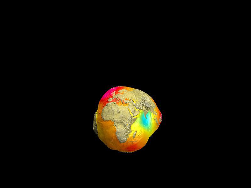
Earth may look like a perfect blue marble in photos taken from space, but it is not precisely round. It’s squashed at the poles, and it bulges at the equator, making it about 43 kilometers (27 miles) wider than it is tall. Parts of the globe, such as Scandinavia and northern Canada, are rising into the air, still rebounding after the weight of the great northern ice sheets disappeared thousands of years ago at the end of the last ice age. The planet also shapeshifts throughout the year as mass moves around on its surface—as when ice melts in the summer or water cycles between the ocean and atmosphere during an El Niño.
All this information, and much more, feeds into something called the International Terrestrial Reference Frame (ITRF), the system scientists use to locate terrestrial observations. Think of it as a global web of coordinates that defines where any particular spot on Earth is at any given time. “If you want to do any kind of positioning or navigating on Earth or in space, it’s all done within a reference frame,” says Richard Gross, a research scientist and geodesy specialist at NASA’s Jet Propulsion Laboratory in Pasadena, California.
There are thousands of local reference frames in use today, but the ITRF is widely accepted internationally. Without global standards, engineers would have to constantly adjust for local differences, which is exactly what happened during the 2004 construction of the Laufenburg bridge on the Swiss-German border. Swiss engineers used the Mediterranean as their sea-level reference. German engineers used the North Sea. Both groups knew they would have to adjust, since the two seas’ reference levels were 27 centimeters apart. But the correction was made with the wrong sign, resulting in a 54-centimeter error between the two ends of the bridge. It’s the classic example of reference-frame screw-up. “That’s why we are trying our best to provide an accurate global reference frame and promote its use,” says Gross.
Researchers generate the ITRF using data from four different Earth-measuring techniques, including GPS. Last updated in 2014, the system is accurate to within a few centimeters relative to the center of the Earth. But in an increasingly wired world, that level of precision is no longer good enough. “You want the driverless cars to stay in their lane,” says Srinivas Bettadpur, director of the Center for Space Research at the University of Texas at Austin. Geodesy experts are now pushing to improve the accuracy of the ITRF down to one millimeter. That would allow scientists to better measure tiny signals such as sea level rise, which is happening globally at the rate of just over three millimeters a year.
That’s where NASA’s equipment upgrades come in. It takes big facilities to measure tiny changes—that plus the integration of data gathered using different geodetic techniques. “They help each other out because they are completely different types of measurements,” says Jan McGarry, a mathematician at Goddard.
The first and most familiar is GPS. The United States, Europe, Russia, and China each operates its own satellite constellations, which let GPS receivers like the one in your cellphone determine your location to within a meter or so. Scientists can pull additional information from the signals to improve accuracy, but only with a lot of effort. “We can take a system that was really only meant to measure things to a meter or 10 meters, but get it down to a millimeter or two,” says Kristine Larson, a geophysicist and emerita professor at the University of Colorado at Boulder. “Of course, you spend about 1,000 times more money.”
With millimeter precision, researchers can put GPS receivers on opposite sides of a geological fault like California’s San Andreas and watch how they move relative to one another, perhaps hinting at a future earthquake. Or they can put receivers around volcanoes, such as Kilauea in Hawaii, to track how the ground moves up and down as magma shifts beneath it.
GPS isn’t perfect. The satellites drift a tiny bit in their orbits, so errors can creep in, undetected, over time. So geodesists need other techniques to provide an independent check. “The way to improve the reference frame is to run these instruments side by side,” says Larson.

The second-line method, called satellite laser ranging, bounces a laser beam off a satellite and measures how long it takes to return. This technique got its start at Goddard in 1964, just four years after the laser was invented. NASA scientists fired a laser at a satellite called Beacon Explorer-B, which was covered in reflective surfaces, and a telescope measured the beam’s return. Calculations based on that measurement provided the distance to Earth’s center of mass.
Today laser ranging is done off many different kinds of satellites, including NASA’s ICESat-2 launched last year, and a shiny metal-and-glass ball called LAGEOS-2, launched in 1992. NASA operates eight satellite laser ranging stations around the globe, but most of them are outdated. “We buy parts on eBay sometimes to maintain them,” says Merkowitz.
Running a satellite laser-ranging system also takes a lot of time and attention. Operators typically use a radar system mounted alongside the laser to detect airplanes that might stray into the area and automatically shut down the laser. McGarry remembers the old days when operators had to scan the sky with binoculars. “I could only do that for about an hour at a time,” she says.
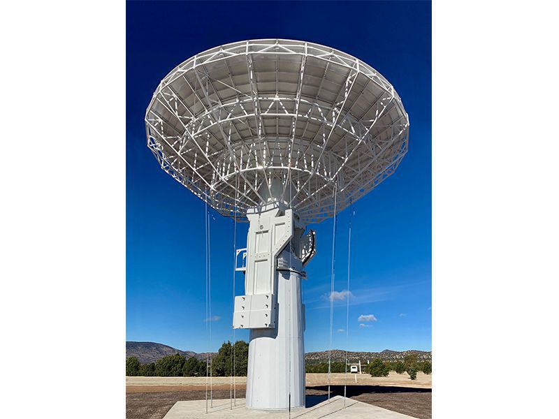
The third tool available to geodesists is very long baseline interferometry, or VLBI. It uses large radio telescopes to clock when radio signals arrive on Earth from quasars, the energetic hearts of massive galaxies billions of light-years away. By noting the difference in arrival times at different VLBI stations around the globe, scientists can calculate small variations in the rotation rate of the planet—due to factors such as the changing seasons, the tides, and weather patterns.
VLBI observations come in spurts, according to Frank Lemoine, a geodesy expert at Goddard. Typically, up to a dozen VLBI stations around the globe will track a set of quasars for up to 24 hours, once or twice a week. These observations are supplemented by one-hour daily sessions. Occasionally, longer campaigns lasting weeks help push the precision even further.
Existing VLBI telescopes have an unfortunate limitation: They can’t move fast enough. One major source of error is the changing atmospheric conditions in the sky over the radio dish; older antennas literally can’t slew fast enough to account for this, Lemoine says. Newer telescopes like one installed on Kauai, Hawaii, in 2016 and the one installed at McDonald this year are faster and therefore more precise.
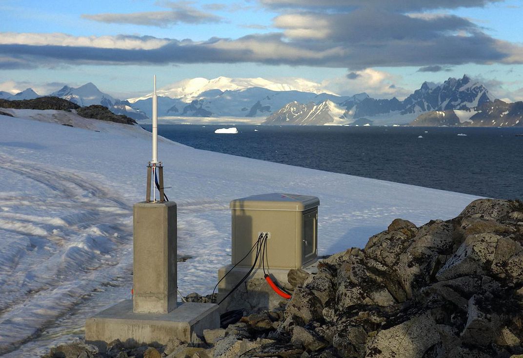
The fourth and final tool used in geodesy—a system called DORIS—sends transmissions from Earth up to special satellites whose receivers calculate their distance from the transmitter based on Doppler shifting of the signal. The French space agency established DORIS in 1990 to help with sea-level measurements, which means DORIS has been observing for longer than any other geodetic network.
The distribution of 50 DORIS transmitters nearly evenly around the globe is an advantage in trying to understand planet-wide changes. Most of the satellite laser-ranging and VLBI stations are in the northern hemisphere. “If all your stations are in Europe, you kind of know what Europe is doing, but you don’t know what South America or Africa is doing,” says Gross.
As NASA upgrades its geodetic networks, it is also working to fix the imbalance. An ideal system would have 24 to 30 stations distributed evenly around the globe, with at least three of the four techniques used at each site, says Merkowitz. That kind of observing network would achieve the ITRF goal of millimeter accuracy. “The big barrier right now is getting that global network in place,” he says.
NASA is spending around $18 million a year on its Space Geodesy Project to update old equipment and bring new instruments online.
International partners are doing their part in this global effort. The Norwegian Mapping Authority is cooperating with NASA to place a satellite laser-ranging system on the Arctic island chain of Svalbard. Situated just 1,000 kilometers from the North Pole, the system will have the best view of polar-orbiting satellites as they fly overhead. It should be up and running by 2024.
NASA is also working with the French space agency to upgrade equipment in Tahiti and has collaborators in Australia, South Africa, and Brazil. “We’re looking continent by continent,” Merkowitz told his audience at a meeting of the American Geophysical Union in December.
* * *
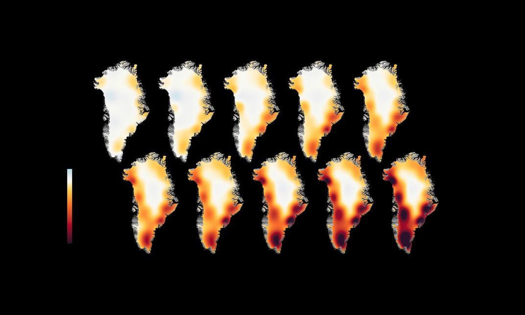
Twin satellites launched in 2002, then succeeded by a follow-on mission launched last year, have given geodesists another powerful yardstick for fine measurements of Earth-size change. Geophysicist Isabella Velicogna, at the University of California, Irvine, uses them to track how the Greenland and Antarctic ice sheets lose weight in the summer as ice melts and gain it back in the winter as snow piles up and freezes. The U.S.-German satellites, known as GRACE, for Gravity Recovery and Climate Experiment, measure the changing force of gravity at Earth’s surface.
The twin GRACE satellites fly about 220 kilometers apart and use microwaves and lasers to measure the distance between them very precisely. When the leading satellite passes over an object with a lot of mass, like a mountain range or an ice sheet, it is tugged ever so slightly forward, and the distance between the two satellites increases. When the trailing satellite approaches that same mountain range or ice sheet, it too is tugged forward and the gap gets shorter. GRACE can measure changes in distance as small as the width of a human blood cell.
Thanks in part to GRACE, we know that Greenland is losing about 280 billion tons of ice a year, on average, while Antarctica is losing just under 120 billion tons a year.
Meanwhile, NASA’s ICESat-2 satellite bounces laser beams down from orbit that reflect off the ice. By precisely measuring the return time, ICESat-2 can build up a three-dimensional picture of the crags and crevasses in the ice below. Over a period of years, scientists can watch how the ice is changing. “Now we’re going to have continuous maps of elevation changes,” says Velicogna. “It’s very exciting.”
Geodesy is crucial in tracking other types of change, including how land drops when farmers pump groundwater for their fields. The U.S. Geological Survey has been measuring these changes in places like California’s agricultural valleys for decades. As the GPS measurements get more precise, researchers can better see how pumping water in one location changes conditions in another, says Michelle Sneed, a hydrologist with the USGS in Sacramento, California.
Land subsidence is a big problem because it damages buildings and other infrastructure. In the past several years in the San Joaquin Valley, parts of the Friant-Kern Canal have sunk as much as a meter, meaning that water managers can’t always deliver water to all the places it’s needed. While some blamed the recent California drought for the subsidence, GPS measurements showed that some parts of the land continued to sink even after the drought ended.
It’s important for managers to understand how groundwater pumping contributes to the problem. “They really need to know what’s happening, in really precise measurements,” Sneed says.
More globally, geodesy is helping officials understand natural hazards such as hurricanes and tsunamis. Precise satellite measurements of sea-surface height, for example, can tell forecasters whether there might be a pool of warm water in the path of an advancing hurricane—which helps them predict how strong the hurricane might grow.
All these planetary measurements, the routine as well as the unusual, require that we keep our geodetic networks up to date. “We often call ourselves the invisible infrastructure,” says Merkowitz. “It’s kind of like the electricity grid. People don’t think about it being there, but if you ever took it away, it would be disastrous.”
Source: Air & Space