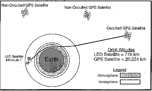
This technique of active limb sounding using radio occultation when the signal path from a GPS satellite to a low Earth orbiting (LEO) satellite intersects the Earth's atmosphere, was first used for planetary atmosphere studies by the Stanford University Center for Radar Astronomy and the Jet Propulsion Laboratory. The principle involved is that the atmosphere acts as a spherical lens, bending and slowing the propagation of signals. Given accurate positions for the two satellites, the atmospheric delay can be determined.
As a signal passes through the atmosphere, it curves due to variations
in the refractive index. The total effect of the bending of a ray by the
atmosphere is indicated by the total refractive bending angle, ![]() .
.
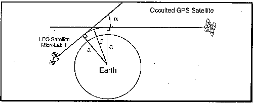
![]() varies with the impact parameter, a, which is the perpendicular
distance between the center of the Earth and the straight line GPS signal
ray path incident to the atmosphere. With accurate knowledge of the GPS
orbits and the orbit of the LEO satellite, ionosphere-free phase data can
be converted into values for
varies with the impact parameter, a, which is the perpendicular
distance between the center of the Earth and the straight line GPS signal
ray path incident to the atmosphere. With accurate knowledge of the GPS
orbits and the orbit of the LEO satellite, ionosphere-free phase data can
be converted into values for ![]() and a.
and a.
![]() as a function of a over the occultation can be converted to a
profile of atmospheric refractive index,
as a function of a over the occultation can be converted to a
profile of atmospheric refractive index, ![]() , as a function of radial distance
from the center of the Earth by
, as a function of radial distance
from the center of the Earth by
![]()
where rm is the distance of the layer from the center of mass of the Earth, and am is the impact parameter for the ray whose radius of closest approach is rm. This equation assumes that the layers of the atmosphere are homogeneous shells of constant refractivity. Ignoring this assumption increases the level of complexity in creating the profile.
In converting profiles of refractive indices to temperature, pressure, and density of the atmosphere, it can be assumed that the air above 8-10 km is "dry" (5-7 km [Ware et al., 1996]). That is, the contribution of water vapor in the atmosphere at the higher altitudes is largely negligible compared with the accuracy of the data.
To form profiles of the atmospheric parameters, the refractivity is related to the air density by
![]()
which combines the relation of refractivity to pressure/temperature ratio and the equation of state. The density can be related to the pressure by integrating the equation of hydrostatic equilibrium. The temperature can then be obtained from the equation of state.
Due to the precision of the measurements of![]() , the vertical profiles of the
atmospheric parameters in the dry air can be obtained with high precision.
, the vertical profiles of the
atmospheric parameters in the dry air can be obtained with high precision.
Below 10 km, the moisture in the air is no longer negligible. In this region of the atmosphere, both the temperature and water vapor can not be solved for from the GPS data alone. Thus, independent models or data are required for either the temperature or the water vapor, depending on which is of interest. The water vapor pressure,e, in terms of the temperature, T, pressure, P, and the refractivity, N, can be expressed as:
![]()
For this to work best, the temperature profiles need to be free of large changes.
Although the density, temperature, pressure, and water vapor, may not be easily extracted from the GPS/MET data, the refractivity will still be available. According to Ware et al. [1996], some researchers are investigating the use of refractivity profiles and bending angles directly in weather models.
Currently, the GPS/MET receiver aboard the MicroLab-1 is operating as a proof of concept test bed that this technique is both effective and economical. It is in a 100 minute circular orbit inclined 70 degrees and provides approximately 500 occultation opportunities per day. High rate, high accuracy data requires double differencing between two gps satellites, the GPS/MET, and a fiducial site on the ground.
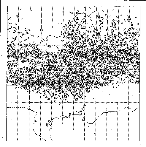
An example of coverage for a fiducial site (Fairbanks, AK) over a 55 day period is below [Ware et al., 1995]. To make your own map of occultations click here.
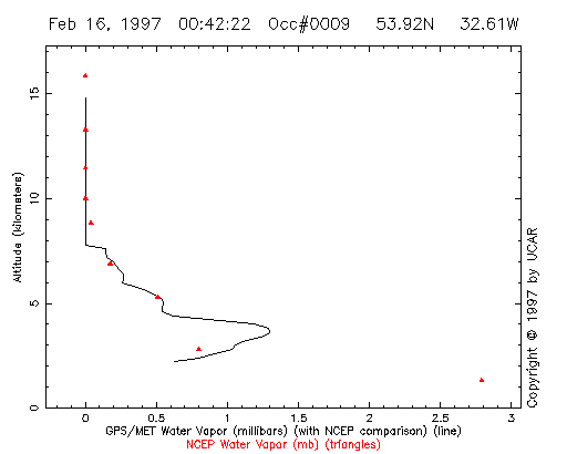
The UCAR GPS/MET web site has archived the differing levels of data including the RINEX, the refractivity, and the atmospheric parameters (temperature, density, pressure). The web site has an interactive feature that allows you to download images and or data for requested times. An example is the water vapor profile below that shows the GPS/MET derived water vapor (mbars) as the solid line, with NCEP values to compare against as the red triangles. The data for this plot came from Occulation #0009 on 2/16/97.
To find other GPS related data, click here.
UCAR - By far,
one of the best and most complete sites on the topic. If you can't find
it here... go to the library!
References
Return to Water Vapor from GPS Receivers
This page created for Remote Sensing course at the University of Texas at Austin.