NASA, CSR, and Oregon State University Collaborate to Release ICESat-2 Global Bathymetry Data Product
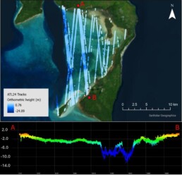
NASA’s National Snow and Ice Data Center Distributed Active Archive Center (NSIDC DAAC) released the ATLAS/ICESat-2 Level 3A Along Track Coastal and Nearshore Bathymetry (ATL24), Version 1 dataset, which provides global along-track coastal and near-shore bathymetry data consisting of refraction-corrected seafloor and sea surface heights as well as associated uncertainty estimates.
The data product, ATL24, is the first global, space-based bathymetry product and will assist broadly with improving navigation safety and maritime security was a collaboration between Dr. Lori Magruder’s research team and Oregon State University.
Source: https://www.earthdata.nasa.gov/news/new-global-icesat-2-bathymetric-data-fills-near-shore-data-voids